SIU Director’s Report - Case # 21-OVI-274
Warning:
This page contains graphic content that can shock, offend and upset.
Contents:
Mandate of the SIU
The Special Investigations Unit is a civilian law enforcement agency that investigates incidents involving an official where there has been death, serious injury, the discharge of a firearm at a person or an allegation of sexual assault. Under the Special Investigations Unit Act, 2019 (SIU Act), officials are defined as police officers, special constables of the Niagara Parks Commission and peace officers under the Legislative Assembly Act. The SIU’s jurisdiction covers more than 50 municipal, regional and provincial police services across Ontario.
Under the SIU Act, the Director of the SIU must determine based on the evidence gathered in an investigation whether there are reasonable grounds to believe that a criminal offence was committed. If such grounds exist, the Director has the authority to lay a criminal charge against the official. Alternatively, in cases where no reasonable grounds exist, the Director cannot lay charges. Where no charges are laid, a report of the investigation is prepared and released publicly, except in the case of reports dealing with allegations of sexual assault, in which case the SIU Director may consult with the affected person and exercise a discretion to not publicly release the report having regard to the affected person’s privacy interests.
Under the SIU Act, the Director of the SIU must determine based on the evidence gathered in an investigation whether there are reasonable grounds to believe that a criminal offence was committed. If such grounds exist, the Director has the authority to lay a criminal charge against the official. Alternatively, in cases where no reasonable grounds exist, the Director cannot lay charges. Where no charges are laid, a report of the investigation is prepared and released publicly, except in the case of reports dealing with allegations of sexual assault, in which case the SIU Director may consult with the affected person and exercise a discretion to not publicly release the report having regard to the affected person’s privacy interests.
Information Restrictions
Special Investigations Unit Act, 2019
Pursuant to section 34, certain information may not be included in this report. This information may include, but is not limited to, the following:- The name of, and any information identifying, a subject official, witness official, civilian witness or affected person.
- Information that may result in the identity of a person who reported that they were sexually assaulted being revealed in connection with the sexual assault.
- Information that, in the opinion of the SIU Director, could lead to a risk of serious harm to a person.
- Information that discloses investigative techniques or procedures.
- Information, the release of which is prohibited or restricted by law.
- Information in which a person’s privacy interest in not having the information published clearly outweighs the public interest in having the information published.
Freedom of Information and Protection of Privacy Act
Pursuant to section14 (i.e., law enforcement), certain information may not be included in this report. This information may include, but is not limited to, the following:- Confidential investigative techniques and procedures used by law enforcement agencies; and
- Information that could reasonably be expected to interfere with a law enforcement matter or an investigation undertaken with a view to a law enforcement proceeding.
- The names of persons, including civilian witnesses, and subject and witness officials;
- Location information;
- Witness statements and evidence gathered in the course of the investigation provided to the SIU in confidence; and
- Other identifiers which are likely to reveal personal information about individuals involved in the investigation.
Personal Health Information Protection Act, 2004
Pursuant to this legislation, any information related to the personal health of identifiable individuals is not included.Other proceedings, processes, and investigations
Information may also have been excluded from this report because its release could undermine the integrity of other proceedings involving the same incident, such as criminal proceedings, coroner’s inquests, other public proceedings and/or other law enforcement investigations.Mandate Engaged
Pursuant to section 15 of the SIU Act, the SIU may investigate the conduct of officials, be they police officers, special constables of the Niagara Parks Commission or peace officers under the Legislative Assembly Act, that may have resulted in death, serious injury, sexual assault or the discharge of a firearm at a person.
A person sustains a “serious injury” for purposes of the SIU’s jurisdiction if they: sustain an injury as a result of which they are admitted to hospital; suffer a fracture to the skull, or to a limb, rib or vertebra; suffer burns to a significant proportion of their body; lose any portion of their body; or, as a result of an injury, experience a loss of vision or hearing.
In addition, a “serious injury” means any other injury sustained by a person that is likely to interfere with the person’s health or comfort and is not transient or trifling in nature.
This report relates to the SIU’s investigation into serious injuries sustained by a 17-year-old male (“Complainant #1) and a 28-year-old male (“Complainant #2”).
The Investigation
Notification of the SIU
On August 27, 2021, at 3:15 a.m., the Peel Regional Police (PRP) reported the following.At 9:05 p.m., on August 26, 2021, a PRP officer was conducting radar when a vehicle passed him at high speed. The officer activated his emergency equipment and pursued the vehicle on Mayfield Road in Brampton. The vehicle drove into the oncoming lanes and the officer drove parallel to warn oncoming traffic. The vehicle collided head-on with a vehicle on Mayfield Road east of Torbram Road.
The driver of the pursued vehicle, identified as Complainant #1, was at St. Michael’s Hospital (SMH) with minor injuries. The driver of the vehicle that was struck, identified as Complainant #2, was at Sunnybrook Health Sciences Centre (SHSC) with various injuries, including a fractured back and pelvis.
The involved officer was the Subject Official (SO).
The Team
Date and time team dispatched: 08/27/2021 at 4:06 a.m.Date and time SIU arrived on scene: 08/27/2021 at 5:41 a.m.
Number of SIU Investigators assigned: 5
Number of SIU Forensic Investigators assigned: 2
Number of SIU Collision Reconstructionists assigned: 1
The SIU entered into an agreement with the PRP Reconstruction Team that they would conduct a parallel investigation, as they had criminal charges to support. Also, all book/field notes and sketches from the police reconstructionist, and/or the police officer who prepared the motor vehicle collision report, all scene photographs, measurements and diagrams, as well as data from the involved police vehicle, including Automatic Vehicle Locator (AVL)/Global Positioning System (GPS) data, and all Crash Data Retrieval (CDR) reports from other vehicles involved in the collision, would be provided to the SIU so that the SIU reconstructionist could analyze the events around the collision.
The involved BMW and Hyundai were maneuvered to attempt to replicate their positioning prior to the collision.
The Forensic Investigators completed the scene examination, took photographs, and measured the scene with a Total Station device for forensic mapping purposes.
The SIU reconstructionist analyzed the events in and around the time of the collision.
The area was also canvassed for witnesses and security camera footage.
Affected Persons (aka “Complainants”):
Complainant #1 Declined interview; medical records obtained and reviewedComplainant #2 Interviewed; medical records obtained and reviewed
Complainant #2 was interviewed on September 17, 2021.
Civilian Witnesses
CW Interviewed The civilian witness was interviewed on August 27, 2021.
Subject Officials
SO Interviewed, and notes received and reviewed The subject official was interviewed on September 8, 2021.
Witness Officials
WO #1 Interviewed WO #2 Interviewed
WO #3 Notes reviewed; interview deemed not necessary
WO #4 Not interviewed; reconstruction report received and reviewed
WO #5 Notes reviewed; interview deemed not necessary
WO #6 Notes reviewed; interview deemed not necessary
The witness officials were interviewed on September 1, 2021.
Evidence
The Scene
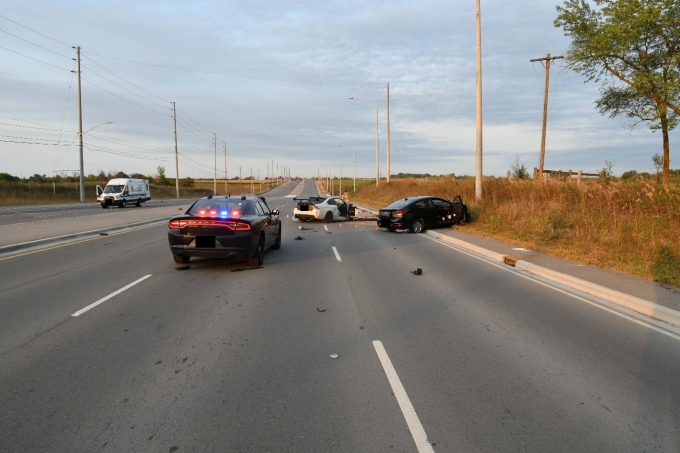
The collision occurred on Mayfield Road, .6 kilometres east of Torbram Road. The weather was clear and hot. The roads were dry.
Mayfield Road ran in a general east-west direction. The roadway was paved with three marked lanes in each direction and separated with a raised centre island. The lane markings were present and in good repair. There were streetlights on either side of the roadway. The posted speed limit was 80 km/h. The roadway was relatively straight with low hills. The area was mostly rural. There was a break in the raised centre island that allowed for a turn-around east of the collision.
Three vehicles were contained within the scene as follows:
A 2007 white two-door BMW. The vehicle was oriented in a northwest direction over lanes two and three of the three westbound lanes. The vehicle had extensive front-end collision damage. The vehicle’s front and side air bags had deployed with bloodstaining on the driver’s front air bag. The speedometer was analog, and the display stick was stuck at 98 km/h. The tachometer was analog, and the display stick was stuck at 2400 rpm.
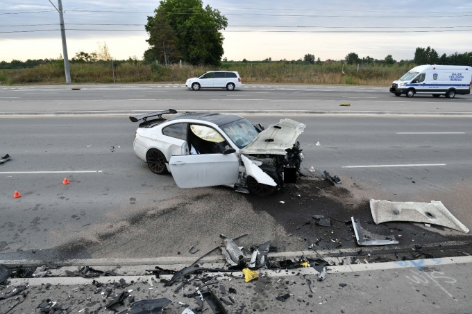
Figure 2 - The BMW with extensive front-end damage.
A 2020 black four-door Hyundai Elantra. The vehicle was orientated in a northwest direction over the north side curb and lane three of the three westbound lanes, and east of the BMW vehicle. The vehicle had extensive front-end collision damage (heavy intrusion damage on front left). The vehicle’s driver’s front and driver’s side airbags had deployed. The speedometer was analog, and the display stick was stuck at 82 km/h. The tachometer was analog, and the display stick was stuck at 1700 rpm.

Figure 3 - The Hyundai Elantra with extensive front-end damage.
A 2018 black four-door Dodge Charger. An unmarked police cruiser with emergency lighting and siren as designed by the PRPS. The vehicle was running with its emergency lighting on and functioning as designed. The vehicle’s siren and horn were checked and functioned properly. The vehicle was orientated in a westerly direction in lane two of the three westbound lanes and east of the Hyundai. There was a Genesis 2 moving radar system on the front dash-driver’s side. The vehicle had no apparent new collision damage.
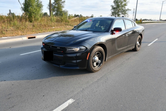
Figure 4 - The Dodge Charger.
There were gouge marks indicating the impact area in the centre westbound lane (lane # two) and west of the white BMW. The BMW was being operated eastbound in the westbound lanes and the Hyundai was being operated westbound in the westbound lanes.
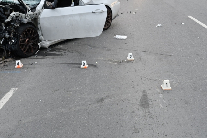
Figure 5 - Marks on the road near the BMW.
There was a slight rise in the roadway as one proceeded eastbound on Mayfield Road. There was a slight decline in the roadway as one proceeded westbound on Mayfield Road.
Scene Diagram
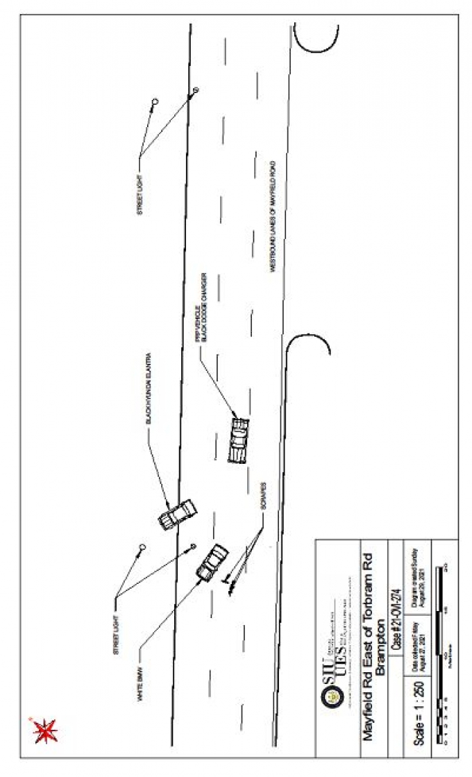
Pursuit route
Route 1
The route commenced on Dixie Road south of Mayfield Road, and proceeded east on Mayfield Road from Dixie Road. The area was primarily an undeveloped rural setting. At .4 kilometres into the pursuit, there was a posted 80 km/h advisory sign. There was a new residential community on the south side. At .7 kilometres, there was a 60 km/h ahead advisory sign. At 1 kilometre, there was a 60 km/h advisory sign. Mayfield Road’s intersection with Bramalea Road was at 1.4 kilometres. The intersection was controlled with overhead traffic signals. There was overhead streetlighting on both sides of Mayfield Road. Continuing east in the southeast corner of the intersection was a Smart Centre Complex with numerous stores. In the northeast corner was Mayfield Secondary School. There were posted signs continuing east of Mayfield Road of the school zone and a speed advisory of 40 km/h when flashing.
East of the plaza and school, the area was primarily rural on either side of the roadway. At 1.8 kilometres, there was a 60 km/h advisory sign. At 2.2 kilometres, there was an 80 km/h advisory sign.
The intersection with Torbram Road was at 2.8 kilometres. There were left (northbound) and right (southbound) turn lanes as well as the three eastbound lanes. The traffic signals appeared to be functioning.
Continuing east through the intersection there were three eastbound and three westbound lanes with a raised centre island. There was overhead lighting on both sides of the roadway. The area was primarily rural on both sides of the roadway.
At 3.1 kilometres, there was an 80 km/h advisory sign.
The collision scene was at 3.4 kilometres.
Route 2
The BMW commenced its travel at a sports field on Kennedy Road. The route commenced on Kennedy Road north of Bramalea Road and concluded at the scene of the collision – a total distance travelled of 6.9 kilometres.Expert Evidence
On October 12, 2021, the SIU received the PRP reconstructionist report, a summary of which follows.Scene Evidence
This collision involved two vehicles. The collision occurred in the middle of the westbound lanes of Mayfield Road. After the collision, both vehicles were re-directed toward the northeast. Evidence consisted of the following:- Hyundai Elantra with severe front-end damage and airbags deployed.
- BMW 35i with severe front-end damage and airbags deployed.
- Scrape and gouge marks within the middle westbound lane
- Large debris field of vehicle parts and pieces.
With this information, consideration was given to conducting momentum analysis to determine the speeds of the involved vehicles. The Hyundai struck and mounted the north curb before coming to rest and the BMW made an unknown number of rotations prior to stopping. As a result, post-impact speeds could not be confidently calculated for either vehicle. Without a reliable post-impact speed, the results of any traditional momentum analysis could not be relied upon. However, the Event Data Recorder (EDR) of the Hyundai was able to be downloaded and analyzed to determine the speed of the Hyundai and the BMW.
Speed Analysis
The Hyundai Elantra was travelling westbound on Mayfield Road. The Hyundai was travelling in the left most passing lane. The BMW 35i was eastbound on Mayfield Road. The BMW was also travelling in the left most passing lane of westbound Mayfield Road as he was attempting to avoid police. The BMW travelled 673.2 metres from Torbram Road to the impact location, in the wrong direction against the traffic of the westbound lanes. Both vehicles attempted to avoid collision by moving into the centre lane of westbound traffic where they collided. After impact, the Hyundai’s path of travel was re-directed northeast. Scrapes and tire marks left by the BMW indicated that its travel was also altered northeast post-collision.The Hyundai struck and mounted the north curb of Mayfield Road. The BMW rotated and came to rest in the westbound lanes of Mayfield Road. Due to these factors, post-impact speeds for the vehicles could not be determined and traditional momentum calculations were inapplicable.
The Bosch Diagnostic tool did not support the involved 2008 BMW’s Airbag Control Module (ACM). As such, the speed at which the BMW struck the Hyundai could not be obtained through this method. The Hyundai Elantra’s ACM was supported by Bosch and was successfully downloaded.
Speed Calculations
The EDR of the Hyundai was removed and downloaded through the CDR tool. There was one event recorded on the Hyundai’s EDR. The speed of the Hyundai was captured for a period of five seconds before the crash. The data showed that that vehicle had accelerated from 88 km/h up to 92 km/h during the preceding five seconds leading up to the collision. One second before impact there was steering input and brake application. The driver steered to the right while braking, reducing the vehicle speed to 79 km/h at impact. Of interest, the speedometer of the Hyundai locked at approximately 85 km/h due to catastrophic energy loss. These data were consistent with the Hyundai driving normally at speed along Mayfield Road in his lane and, once the driver realized a vehicle was heading directly at him within that lane, the driver attempting to avoid the collision by braking and steering to the right. The damage profile indicated the force applied by the BMW to the Hyundai was from the front with a slight driver side to the passenger side angle. The post-impact speed of the Hyundai at the moment of separation from the BMW was 22 km/h.
The calculations suggested that the BMW was travelling 104 km/h at impact. This calculation was based on an approach angle of 142.2 degrees between the vehicles. If the angles were off slightly due to post-collision damage to the Hyundai that prevented the accurate placement of the vehicles together, then the angles could be off by up to ±5 degrees. By changing the angle of approach, one could calculate a range of speed for the BMW. Substituting in the values, one obtained a range of 115 km/h at 137.2 degree approach angle on the high end and 95 km/h at an approach angle of 147.2 degrees on the low end. However, like the Hyundai, the speedometer of the BMW also locked upon impact due to catastrophic energy loss. The speedometer locked-in at 95 km/h.
There were no pre-impact tire marks identified upon the roadway for either vehicle. From the Hyundai data, it is apparent that the driver did see the impending collision with the BMW. He applied the brakes, and there was steering input to the right, suggesting emergency actions being taken.
Although no skid marks were present, it could not be concluded that the BMW failed to apply its brakes prior to colliding with the Hyundai. This was due to the fact that if the brakes were applied time/travel distance was required for sufficient heat to be generated due to friction between its tires and the roadway surface for a skid mark on the roadway to be generated.
Conclusions
- Environmental factors such as lighting, weather and road conditions were not factors in this collision.
- The mechanical fitness of the BMW was not a factor in this collision.
- Speed was a factor in the severity of the collision.
- The Complainant was driving the wrong way in the westbound lanes of Mayfield Road.
- Complainant #1 was a G1 driver and did not have a valid accompanying driver with him at the time of the collision.
- The roadway was clearly marked and had a wide raised median to separate eastbound and westbound traffic.
- Complainant #2 was driving properly, within his designated lanes of travel, prior to the collision.
- Complainant #1 was solely responsible for this collision occurring by driving for over 673 metres, at speeds over 100 km/h, eastbound within the westbound lanes.
On October 26, 2021, the SIU reconstructionist noted that, upon his review of the PRP reconstruction report, and his own independent analysis based on the physical evidence and the provided materials, he was generally in agreement with the PRP report conclusions:
- The collision occurred in the westbound middle lane of Mayfield Road. The Hyundai was travelling westbound at the time, while the BMW was travelling eastbound.
- The BMW was likely travelling just over 100 km/h at impact.
- The Hyundai was travelling about 79 km/h at impact.
- The Hyundai EDR data were consistent with the physical evidence and were therefore considered reliable data.
- The impact between the vehicles was essentially head-on, with both vehicles turned towards the north just before impact. This meant Complainant #2 steered to the right just before impact, and Complainant #1 steered to the left just before impact.
- The SIU reconstructionist arrived at the following other findings.
Police GPS Data Analysis
The AVL data included a time stamp to the nearest 1 second, a distance estimate based on the distance travelled between the current point and the previous point, and a speed estimate. It was unknown how the AVL software determined the speed estimate. The location data and the time stamps were used to determine the average speed of the cruiser as it travelled between the two points. At 9:03:38 p.m., the police vehicle was stopped on the side of Mayfield Road about 150 metres west of Bramalea Road. This was the location of the police vehicle while the SO was conducting speed radar.
At 9:04:01 p.m., the police vehicle was located in front of Mayfield High School about 200 metres east of Bramalea Road. The AVL data indicated the vehicle was travelling about 129 km/h at this time. Since there was no data indicating when the police vehicle started to move eastbound, the AVL speed reading could not be verified. However, given the time and distance between locations, it was possible the SO slowed or stopped before entering the Bramalea Road intersection and accelerated up to speed. In addition, it should be noted that this section of road was a 60 km/h zone with a posted 40 km/h maximum speed during school hours. This area was also a designated Community Safety Zone due to the proximity of the high school to the north and the shopping area to the south.
At 9:04:09 p.m., the police vehicle was located about 320 metres further to the east. The AVL data recorded a speed of 153 km/h at this data point. Given that the police vehicle travelled 320 metres in eight seconds, it appears the police vehicle was travelling an average of about 144 km/h over these two locations.
At 9:04:17 p.m., the police vehicle was located about 345 metres further east. The AVL data recorded a speed of 153 km/h at this location. Based on the distance travelled over 8 seconds, the vehicle was travelling an average speed of 155 km/h. Mayfield Road transitioned from a 60 km/h speed limit to an 80 km/h speed limit as it approached this AVL location.
At 9:04:25 p.m., the police vehicle was located about 325 metres further east. The AVL data recorded a speed of 95 km/h at this location. Based on the distance travelled over eight seconds, the vehicle was travelling an average speed of 146 km/h.
At 9:04:45 p.m., the police vehicle was located about 320 metres further east. The AVL data recorded a speed of 92 km/h at this location. Based on the distance travelled over 20 seconds, the vehicle was travelling an average speed of 58 km/h. it should be noted that that the police vehicle passed through the intersection with Torbram Road before reaching this AVL location. The conditions required for the police vehicle to stop and safely negotiate the intersection given its approach speed to the intersection were calculated. It was found that there was enough time for the SO to slow or stop briefly before entering the intersection and then accelerate to reach the next AVL location in the required time.
At 9:04:55 p.m., the police vehicle was located 340 metres further east. The AVL recorded a speed of 134 km/h at this location. Based on the distance travelled in ten seconds, the police vehicle was travelling an average of 122 km/h over this distance.
The final location was first recorded at 9:05:39 p.m. This was the police vehicle’s final rest position. Based on the scene evidence, the vehicle was stopped in the westbound lanes facing west. This suggested the police vehicle continued east just past the collision location and completed a U-turn before coming to rest. The AVL data recorded a speed of 0 km/h. Based on the time and distance travelled, the police vehicle was travelling an average of about 24 km/h.
Video/Audio/Photographic Evidence [1]
The SIU obtained audio and photographic records of relevance, as set out below. On September 7, 2021, the SIU received radio communications from the PRP, a summary of which follows:
At 9:05:34 p.m., the SO requests units up on Mayfield east of Torbram and two ambulances, as a head-on collision had occurred.
At 9:06:19 p.m., the SO indicates there are two vehicles involved; there are two people in one vehicle and one in the other. One driver in one vehicle is unconscious, and both parties in the other vehicle are conscious. The officer needs Mayfield shut down westbound at Airport Road.
At 9:09:43 p.m., the SO reports the man in the second vehicle is in rough shape.
At 9:33:55 p.m., the SO reports the man in custody is Complainant #1.
At 9:37:15 p.m., dispatcher provides the results of a check on Complainant #1, which includes information about the unauthorized possession of a prohibited weapon in July 2021.
At 10:28:45 p.m., a police officer gives an update on injuries, and notes that victim and accused are being transferred to a trauma centre - both have head injuries, the victim has fluid in his stomach, and they are prepping for transport shortly.
****
On September 8, 2021, the SIU received a photo of the radar screen taken by the SO.
On September 21, 2021, PRP provided photos of the scene.
Materials Obtained from Police Service
The SIU obtained and reviewed the following records from the PRP:- Computer-assisted Dispatch Incident History;
- Communications Audio Report-Phone;
- Communications Audio Report-Radio;
- Directive - Traffic Management and Strategic Enforcement Policy;
- Directive - Suspect Apprehension Pursuit Policy;
- EDR Report;
- Notes of the SO, WO #1, WO #2, WO #3, WO #5, WO #6 and two undesignated officers;
- Occurrence Report;
- Officer list;
- Photo taken of radar gun by the SO;
- PRP Photographs;
- PRP AVL Data;
- PRP Reconstruction (Total Station Points);
- PRP Reconstructionist Report;
- PRP Reconstructionist AVL Video; and
- PRP Vehicle Safety Report.
Materials Obtained from Other Sources
The SIU obtained and reviewed the following records from the Brampton Fire Department, Peel Emergency Medical Services (EMS), Brampton Civic Hospital (BCH), SMH, and SHSC: - Peel EMS Ambulance Call Reports (×2);
- Fire Department Report;
- Witness Statement-Firefighter Observations;
- Medical Record-BCH;
- Medical Records-SMH; and
- Medical Record-SHSC.
Incident Narrative
The material events are clear on the evidence collected by the SIU, which included interviews with the SO, Complainant #2 and the CW – a passenger in Complainant #1’s vehicle at the time, as well as a review of data associated with the speeds of the involved vehicles.
Complainant #2 was travelling west in his Hyundai Elantra on Mayfield Road, about 600 metres east of Torbram Road, when his vehicle was struck by a BMW sedan. The BMW was being operated by Complainant #1 the wrong way in the westbound lanes. Both vehicles travelled a distance east following the impact, and came to rest facing northwest in the westbound lanes of traffic, the Hyundai partially over the curb of the road. The time was about 9:05 p.m.
Moments earlier, the SO, in an unmarked police cruiser, had been stationary on a driveway off Mayfield Road about 150 metres west of the Bramalea Road intersection, conducting speed enforcement. He had clocked Complainant #1’s BMW travelling east toward him at about 170 km/h. The speed limit in the area was 60 km/h. As the BMW drove past him, the SO maneuvered onto Mayfield Road and accelerated after Complainant #1. His intention was to stop the BMW for the speeding infraction.
Complainant #1 continued at speed eastward toward Torbram Road. It was just before the intersection that he realized he was being followed by a police officer - the SO – and that the SO wanted him to pull over. The officer had by that time pulled up alongside the BMW’s driver’s side, shone a flashlight into the vehicle, and activated his emergency lights. Complainant #1 initially slowed as if coming to a stop in the curb lane of Mayfield Road. However, he abruptly changed course, maneuvered around the cruiser, and proceeded into the westbound passing lane via the Torbram Road intersection.
With his emergency lights still activated, the SO pursued the BMW in the eastbound passing lane, and watched as two westbound vehicles were able to avoid a collision with Complainant #1’s vehicle. A third motorist – Complainant #2 – appears not to have seen Complainant #1 until it was too late.
Following the collision, the SO drove past the wreckage, made a U-turn, and parked his vehicle behind the BMW and Hyundai to block westbound traffic. The officer called for an ambulance, and proceeded to arrest the driver of the BMW – Complainant #1
Complainant #1 and Complainant #2 were taken from the scene to hospital. The former was diagnosed with fractures of the right foot and spine. The latter was found to have sustained multiple fractures, organ damage, and internal bleeding.
Relevant Legislation
Section 320.13, Criminal Code – Dangerous operation of motor vehicles, vessels and aircraft
320.13 (1) Everyone commits an offence who operates a conveyance in a manner that, having regard to all of the circumstances, is dangerous to the public.
(2) Everyone commits an offence who operates a conveyance in a manner that, having regard to all of the circumstances, is dangerous to the public and, as a result, causes bodily harm to another person.
(3) Everyone commits an offence who operates a conveyance in a manner that, having regard to all of the circumstances, is dangerous to the public and, as a result, causes the death of another person.
Analysis and Director's Decision
On August 26, 2021, Complainant #2 was seriously injured in Brampton when the vehicle he was driving was struck head-on by another vehicle. The driver of that vehicle – Complainant #1 – was also seriously injured in the impact. As a PRP officer had attempted to stop Complainant #1’s vehicle before the collision, the SIU was notified and initiated an investigation. The involved officer – the SO – was identified as the subject official. On my assessment of the evidence, there are no reasonable grounds to believe that the SO committed a criminal offence in connection with the motor vehicle collision.
The offence that arises for consideration is dangerous driving causing bodily harm contrary to section 320.13(2) of the Criminal Code. The offence is premised, in part, on conduct that amounts to a marked departure from the level of care that a reasonable person would have exercised in the circumstances. In the instant case, the question is whether there was any neglect in the manner in which the SO engaged with Complainant #1 that caused or contributed to the collision and/or was sufficiently egregious to attract criminal sanction. In my view, there was not.
The SO was within his rights in seeking to stop Complainant #1 for a serious traffic infraction. The officer had measured Complainant #1’s vehicle speeding at about 170 km/h. Arguably, at that speed, Complainant #1 was not merely in contravention of the speeding laws, he was driving dangerously in violation of the Criminal Code.
I am also satisfied that the SO comported himself with due care and regard for the safety of the public throughout the events in question. The officer did travel at speeds well above the speed limit, at times over 150 km/h, but did not do so at any great risk to the public. Traffic was minimal, the roads were dry, and there was no evidence of any vehicles having been placed at imminent peril by the SO’s cruiser. Moreover, given the velocity at which the BMW was travelling, a degree of speeding was to be expected of the officer if he was to place himself in a position to stop the BMW.
The real issue, in my view, is whether the SO’s decision to continue to follow the BMW, after the vehicle had taken off from him the wrong way in the Mayfield Road westbound lanes, was a prudent one. The officer had a difficult decision to make. By that time, the SO had taken note of the BMW’s licence plate and had cast eyes on the driver and passenger, both of whom were young persons. In the circumstances, he might have decided to forego any further engagement to mitigate the risk of continued reckless driving by Complainant #1. Instead, the SO decided to follow the BMW, on a parallel track but in the proper lanes of travel a distance behind. His aim was to have westbound motorists alerted to the danger of the approaching BMW by his emergency lights. I am unable to reasonably conclude that the officer’s decision was an imprudent one or, if it was, that it markedly deviated from a reasonable course of action in the circumstances. Complainant #1 had been operating his BMW at dangerous speeds before he was ever aware of the SO’s presence. Given that fact, the SO had some reason to believe that he would continue to do so, at even greater risk to the public on the wrong side of the road, regardless of the officer’s involvement. On this record, the SO’s conduct might well have served to lessen the risk to public safety created by Complainant #1.
In the result, there are no reasonable grounds to believe that the SO transgressed the limits of care prescribed by the criminal law in his brief engagement with Complainant #1 over about two kilometres. Accordingly, there is no basis for proceeding with criminal charges in this case, and the file is closed.
Date: December 20, 2021
Electronically approved by
Joseph Martino
Director
Special Investigations Unit
Endnotes
- 1) The following records contain sensitive personal information and are not being released pursuant to section 34(2) of the Special Investigations Unit Act, 2019. The material portions of the records are summarized below. [Back to text]
Note:
The signed English original report is authoritative, and any discrepancy between that report and the French and English online versions should be resolved in favour of the original English report.