SIU Director’s Report - Case # 20-OVI-096
Warning:
This page contains graphic content that can shock, offend and upset.
Contents:
Mandate of the SIU
The Special Investigations Unit is a civilian law enforcement agency that investigates incidents involving police officers where there has been death, serious injury or allegations of sexual assault. The Unit’s jurisdiction covers more than 50 municipal, regional and provincial police services across Ontario.
Under the Police Services Act, the Director of the SIU must determine based on the evidence gathered in an investigation whether an officer has committed a criminal offence in connection with the incident under investigation. If, after an investigation, there are reasonable grounds to believe that an offence was committed, the Director has the authority to lay a criminal charge against the officer. Alternatively, in all cases where no reasonable grounds exist, the Director does not lay criminal charges but files a report with the Attorney General communicating the results of an investigation.
Under the Police Services Act, the Director of the SIU must determine based on the evidence gathered in an investigation whether an officer has committed a criminal offence in connection with the incident under investigation. If, after an investigation, there are reasonable grounds to believe that an offence was committed, the Director has the authority to lay a criminal charge against the officer. Alternatively, in all cases where no reasonable grounds exist, the Director does not lay criminal charges but files a report with the Attorney General communicating the results of an investigation.
Information Restrictions
Freedom of Information and Protection of Privacy Act (“FIPPA”)
Pursuant to section 14 of FIPPA (i.e., law enforcement), certain information may not be included in this report. This information may include, but is not limited to, the following:- Confidential investigative techniques and procedures used by law enforcement agencies; and
- Information whose release could reasonably be expected to interfere with a law enforcement matter or an investigation undertaken with a view to a law enforcement proceeding.
- Subject Officer name(s);
- Witness Officer name(s);
- Civilian Witness name(s);
- Location information;
- Witness statements and evidence gathered in the course of the investigation provided to the SIU in confidence; and
- Other identifiers which are likely to reveal personal information about individuals involved in the investigation.
Personal Health Information Protection Act, 2004 (“PHIPA”)
Pursuant to PHIPA, any information related to the personal health of identifiable individuals is not included. Other proceedings, processes, and investigations
Information may have also been excluded from this report because its release could undermine the integrity of other proceedings involving the same incident, such as criminal proceedings, coroner’s inquests, other public proceedings and/or other law enforcement investigations.Mandate Engaged
The Unit’s investigative jurisdiction is limited to those incidents where there is a serious injury (including sexual assault allegations) or death in cases involving the police.
“Serious injuries” shall include those that are likely to interfere with the health or comfort of the victim and are more than merely transient or trifling in nature and will include serious injury resulting from sexual assault. “Serious Injury” shall initially be presumed when the victim is admitted to hospital, suffers a fracture to a limb, rib or vertebrae or to the skull, suffers burns to a major portion of the body or loses any portion of the body or suffers loss of vision or hearing, or alleges sexual assault. Where a prolonged delay is likely before the seriousness of the injury can be assessed, the Unit should be notified so that it can monitor the situation and decide on the extent of its involvement.
This report relates to the SIU’s investigation into a serious injury sustained by a 53-year-old man (the “Complainant”).
The Investigation
Notification of the SIU
On April 28, 2020, at 8:40 p.m., the Peel Regional Police (PRP) contacted the SIU about an injury. On April 28, 2020, at about 4:05 p.m., a PRP tactical officer saw a suspicious vehicle on North Park Drive in Brampton. A check of the vehicle’s licence plate revealed the vehicle had been reported stolen. Back-up units were requested to the area, but the driver of the stolen vehicle accelerated from the police and a pursuit started.The driver of the stolen vehicle was eastbound on North Park Drive and turned southbound on Torbram Road, disobeying a red traffic signal. The vehicle struck a civilian vehicle that was southbound on Torbram, spinning it into northbound traffic resulting in a multi-vehicle collision.
One of the drivers of a northbound vehicle, the Complainant, was injured and transported to the Brampton Civic Hospital where he was diagnosed with a fractured knee.
The Team
Number of SIU Investigators assigned: 5 Number of SIU Forensic Investigators assigned: 2
Complainant:
53-year-old male interviewed, medical records obtained and reviewedCivilian Witnesses
CW #1 Interviewed CW #2 Interviewed
CW #3 Interviewed
CW #4 Interviewed
CW #5 Interviewed
Witness Officers
WO #1 Not interviewed, but notes received and reviewedWO #2 Interviewed
WO #3 Interviewed
WO #4 Interviewed
WO #5 Interviewed
WO #6 Interviewed
WO #7 Not interviewed, but notes received and reviewed
Additionally, the notes from four other officers were received and reviewed.
Subject Officers
SO Interviewed, and notes received and reviewed Evidence
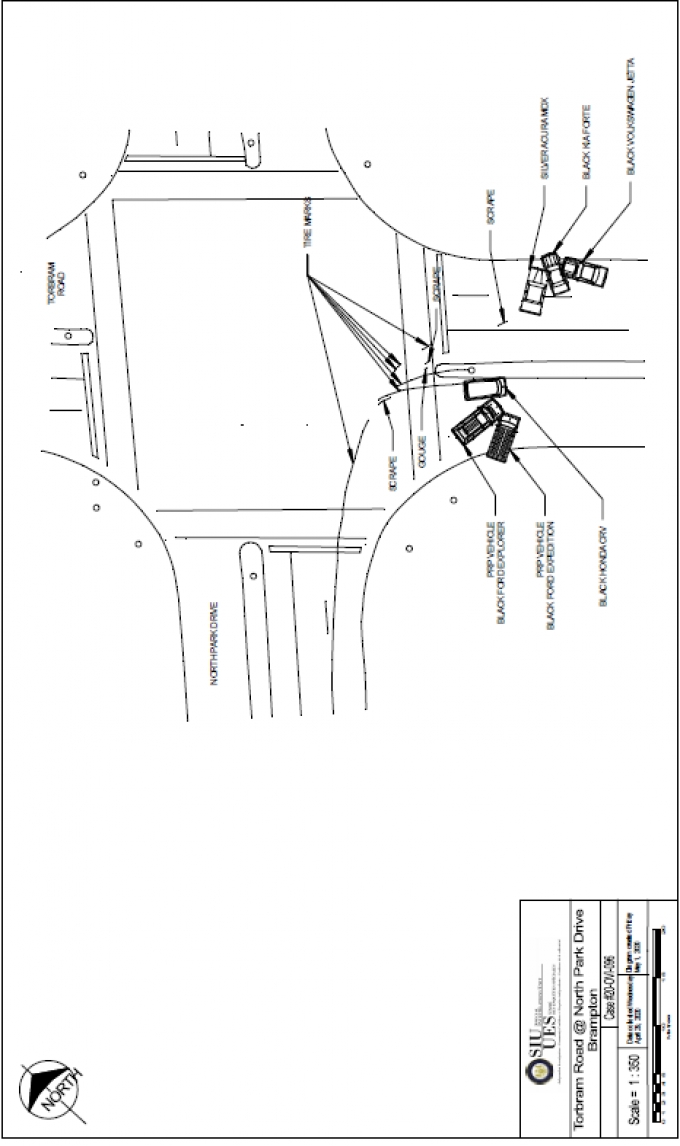
The Scene
The scene was located at the intersection of North Park Drive and Torbram Road in Brampton, Ontario. North Park Drive is a large urban arterial road that runs east and west. It consists of two through lanes in each direction with a dedicated left turn lane for both directions. A raised centre median divides opposing traffic near the intersection and the posted speed limit is 50 km/h. Torbram Road is a large urban arterial road that runs north and south. It consists of two through lanes in each direction with dedicated left turn lanes for both directions. A raised centre median divides opposing traffic near the intersection and the posted speed limit is 60 km/h. The two roads intersect at a right angle and the roads are relatively straight and level in the vicinity of the intersection. The traffic is controlled by traffic signals and there is a pedestrian crosswalk on all four corners of the intersection. A black Honda CRV was found in the southbound lanes of Torbram Road south off North Park Drive, next to the centre median. A Ford Expedition was in contact with the passenger side of the Honda CRV and a Ford Explorer was in contact with the Ford Expedition’s front corner. In the northbound lanes on the other side of the centre median were three vehicles. A silver Acura MDX had passenger side front corner damage, a black Kia Forte had damage to the front end, and a black Volkswagen Jetta also had front end damage.
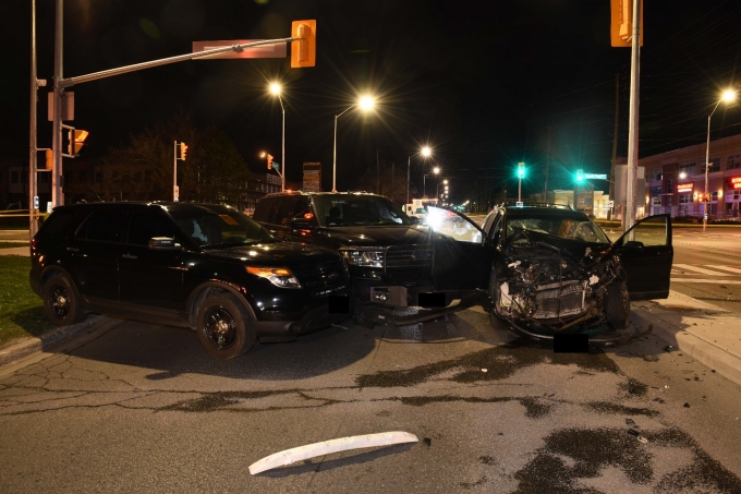
Figure 1 - The Honda CRV, Ford Expedition and Ford Explorer.
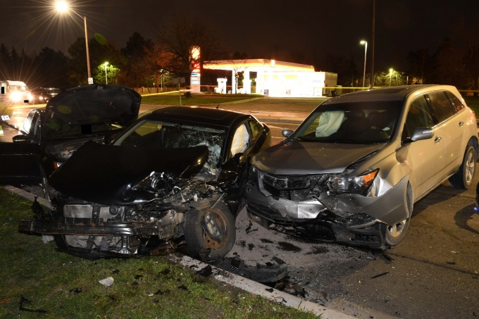
Figure 2 – The Acura MDX, Kia Forte and Volkswagen Jetta.
Scene Diagram
Pursuit Route
The pursuit route began at 40 Middleton Way, a residence in a townhouse complex. The roadway inside the complex had a posted speed limit of 20 km/h and there were several speed bumps along the route to MacKay Street North. The route continued north on MacKay Street North. The roadway was four lanes – two in each direction - within a residential area and the posted speed limit was 40 km/h.
The route continued to a right turn onto Massey Street. Massey Street was a two-laned undivided roadway within a residential area. Massey Street became a community safety zone with a posted speed limit of 40 km/h. This safety zone continued on Massey Street through a school zone with a public school on the south side. Once past the school, the community safety zone ended; the posted speed limit became 50 km/h. Massey Street continued to the Marlborough Street intersection controlled by all-way stop signage.
At Marlborough Street the route continued with a left turn. This roadway was a two-laned undivided roadway within a residential area and at Bramalea Road there was a controlled intersection by traffic light.
The route continued with a right turn on Bramalea Road. This roadway was a four-laned undivided roadway within a residential area with a posted speed limit of 60 km/h to North Park Drive. The intersection was controlled by a traffic light.
The route continued with a left turn onto North Park Drive. The roadway was a four-laned undivided roadway within residential area with a posted speed limit of 50 km/h. While traveling on North Park Drive there was a school zone displaying a posted speed limited of 40 km/h when amber lighting was activated. A school was on the right. After passing through the school zone the speed limit returned to 50 km/h.
The route continued to Torbram Road, where it ended at an intersection controlled by traffic lighting. The total distance of the route was 3.1 kilometres.
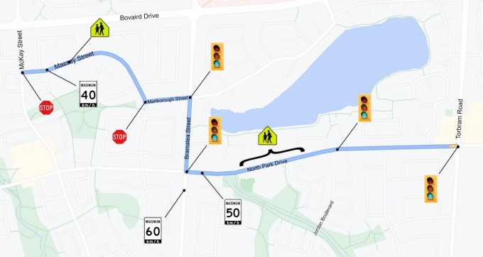
Figure 3 - The pursuit route with traffic signs and stop lights marked.
Police Communications Recordings
Summary of Communication Recording - Telephone Calls
The PRP provided a copy of four audio communication recordings.Track one was a call from an officer [known to be WO #6] to communication reporting he and other tactical units were “sitting on a stolen car” until surveillance officers came up in front of 40 Middleton Way in Brampton. There were five involved units, including WO #2. The stolen vehicle was unoccupied, but the plan was to conduct a high-risk vehicle stop should it go mobile.
In track two, the 911 call-taker answered the phone, but no one was on the telephone. The 911 operator called back; the caller was a gas station attendant at the gas station at North Park Drive and Torbram Road. She said she had seen an accident involving four or five vehicles at the intersection. The call was redirected to the ambulance dispatch.
In track three, the ambulance call-taker called police communications to tell them about a call from a gas station attendant reporting a motor vehicle collision at North Park Drive and Torbram Road.
In track four, the communicator called a sergeant to advise him of the motor vehicle collision.
Summary of Radio Communications
The PRP provided a copy of the radio communication recordings. The communication recordings were not time stamped but had 32 tracks.Track one was one minute and 19 seconds. The TAC sergeant had engaged in a pursuit with a vehicle eastbound on North Park Drive. The stolen vehicle was occupied by two men and one had demonstrated the characteristics of an armed gunman. Approaching Torbram Road, a siren could be heard in the background and a unit reported a canine unit was present. Another unit reported that a man had run north, and the police dog had apprehended him.
Track two was 52 seconds. The TAC sergeant requested three ambulances to the intersection of North Park Drive and Torbram Road. He also gave direction for closure of lanes to the intersection. It was reported that two men had fled the vehicle and a canine unit was tracking. The injuries were minor. There was one man in custody and it was reported another man, the driver, was in custody.
In tracks three to thirty-two, the communications centre relayed information about the motor vehicle collision and the PRP response.
Video/Audio/Photographic Evidence
Summary of Shell Gas Station’s Closed-Circuit Television (CCTV) Video
The Shell gas station was located on the southwest corner of Torbram Road at North Park Drive in Brampton. The intersection was in the upper right corner of the camera. The initial time on the video was 4:10:26 p.m. on April 28, 2020. There was no time stamp but a time counter.At 2:40, northbound traffic on Torbram Road drove through the intersection. Both the northbound and southbound traffic had the green traffic light.
At 2:45, a Honda CRV travelled eastbound on North Park Drive, turned southbound on Torbram Road, and collided with a southbound Acura MDX.
At 2:46, after the collision, a pickup truck, driven by the SO, entered the intersection from the west on North Park Drive. A second pick up truck, driven by WO #2, followed behind. Two men [believed to be CW #4 and CW #5] ran northbound from the collision. WO #2 and his police service dog got out of his vehicle and tracked the men, northbound.
At 5:33, a pickup truck, driven by WO #5, entered the Shell gas station lot and exited southbound on Torbram Road.
Expert Evidence
Reconstructionist Analysis of Shell CCTV
The Shell gas station camera was located at the southwest corner of the intersection. The security camera was facing nominally north and showed the primary collision (Honda and Acura) as well as the eastbound and southbound movement of the Honda, Acura, and police vehicles in the seconds before impact. The video was not time stamped. The meta data embedded within the video reported a resolution of 2048x1536 pixels and a frame rate of 5.9 frames per second (fps). The impact between the Honda and Acura was used as time zero.
The eastbound Honda was first seen about 3.4 seconds before impact. It then exited the camera frame at 2.7 seconds before impact. At 1 second before impact, the southbound Acura entered the frame at the top. At 0.5 seconds before impact, the Honda re-entered the frame as it reached the intersection. Impact occurred at 0 seconds. Both vehicles exited the right side of the frame about 0.5 seconds after impact as the vehicles moved towards their final rest positions.
About 2 seconds before impact, the Ford Expedition [driven by the SO] entered the left side of the camera frame; this vehicle was roughly 1.4 seconds behind the Honda. At 1 second before impact, it exited the top of the frame and then re-entered about 3.7 seconds after impact. At 6.8 seconds after impact, the Ford Expedition collided with something off to the right side of the frame and came to rest.
At about 7 seconds after impact, the Ford Explorer, driven by WO #2, entered the left side of the frame. About 40 seconds later (roughly 45 seconds after impact) the Ford Explorer collided with something off to the right of the frame and came to rest.
There was another black SUV vehicle, driven by WO #5, following behind the Ford Explorer that appeared to be an unmarked police vehicle. WO #5’s vehicle was initially traveling behind the Ford Explorer when the vehicles emerged from the left side of the frame, but instead of continuing straight towards the intersection, WO #5’s police vehicle swerved to the right into the gas station. It then continued through the gas station area, turning to the left to exit the gas station on Torbram Road.
Automatic Vehicle Locator (AVL) / Global Positioning System (GPS) Data
The PRP provided a copy of the AVL / GPS data from five police vehicles, including the Ford Expedition and Ford Explorer. The AVL data were in video format and did not include any GPS co-ordinates. In addition, the time stamp values were only within the nearest 1 second increment. It appeared the data were recorded roughly every 300 metres when the police vehicle was moving or once every 2 minutes when the vehicle was stopped or moving slowly. It was unknown if this was a limitation of the AVL data or if the data obtained by the SIU was pared. It was assumed the AVL time data were synchronized between vehicles.
The AVL data were used to estimate the movement of the vehicles in the moments leading up to the collision. The speeds were interpreted based on the time and distance travelled between AVL data points. In areas where the AVL data was limited, the location of the vehicles was based on the Shell gas station video evidence. The impact between the Honda and the southbound Acura was designated time zero (t = 0 seconds), meaning negative time values were pre-impact and positive time values were after the Honda/Acura impact.
At t = -3.5 seconds (3.5 seconds before the Honda/Acura impact), the lead vehicle in the pursuit - the Ford Expedition [driven by the SO’s vehicle] - was traveling about 94 km/h and located about 130 metres from the intersection. The Ford Explorer, driven by WO #2, was about 70 metres behind the lead police vehicle and traveling roughly 120 km/h. The third police vehicle, driven by WO #6, was about 60 metres behind WO #2’s vehicle and traveling about 117 km/h. The fourth vehicle, driven by WO #5, was another 110 metres to the west and traveling 130 km/h. The last police vehicle, driven by WO #4, was another 30 metres behind and traveling about 128 km/h at this time.
At t = 0 seconds, the impact between the Honda and Acura occurred. At this time, the lead police vehicle, driven by the SO, was about 40 metres west of the intersection and had slowed to 65 km/h. WO #2’s vehicle was about 50 metres behind the lead vehicle and traveling about 85 km/h. WO #6’s vehicle was just under 60 metres behind WO #2’s vehicle and traveling 105 km/h. WO #5’s vehicle was about 90 metres behind WO #6’s vehicle and traveling 124 km/h while WO #4’s vehicle was an additional 30 metres behind and traveling 128 km/h.
At t = 3.5 seconds after impact, the SO’s vehicle had slowed to about 30 km/h and was in the middle of turning right onto Torbram Road. WO #2’s vehicle had slowed to about 40 km/h and was about 40 metres from the intersection. WO #4’s vehicle was located just over 70 metres to the west of the intersection and had slowed to 65 km/h. WO #5’s vehicle was 60 metres from WO #4’s vehicle and still traveling about 110 km/h. WO #4’s vehicle was about 20 metres behind WO #5’s vehicle and was still traveling 128 km/h. Note that the Acura and the northbound Kia likely collided sometime around the 3.5 second mark.
Speed of police vehicles on North Park Drive
The Ford Expedition, driven by the SO, reached its maximum speed of 126 km/h about 500 metres west of the Torbram Road intersection.
The Ford Explorer driven by WO #2 and the other three police vehicles (WO #3, WO #4 and WO #5) all reached their maximum speeds just west of Jordan Boulevard, or about 600 metres east of Bramalea Road. The maximum speed of WO #2’s vehicle was 119 km/h. The maximum speed of WO #4’s vehicle was 126 km/h. The maximum speed of WO #4’s vehicle was 132 km/h. The maximum speed of WO #5’s vehicle was 142 km/h.
Reconstructionist Findings
a) Honda
The only pre-impact information available for the Honda was the Shell gas station video. Based on the video, the Honda was traveling eastbound towards the intersection at a high speed. The vehicle disappeared behind the foliage on the north side of the Shell gas station and then left the edge of the camera frame. The Honda re-emerged on the far side of the frame when it entered the intersection. The impact with the southbound Acura can be seen on the far-right edge of the frame. The reconstructionist estimated the speed of the Honda as it passed the gas station entrance to be about 106 km/h and to be about 60 km/h just before impact. The speed estimate from the video of 60 km/h was consistent with the calculations of the Honda’s impact speed of about 60 km/h based on the physical evidence.
b) Ford Expedition
The Ford Expedition was following behind the Honda by about 1.4 seconds. The vehicle appeared to be traveling about 65 km/h at the time it passed the gas station entrance and slowed to about 20 km/h when it emerged on the far side of the camera frame about 6.1 seconds later in the middle of a right turn.
The AVL data are consistent with the video evidence. The AVL data suggested the Ford Expedition was traveling about 70 km/h as it passed the gas station entrance, slowed to just under 50 km/h as it turned right, and was traveling slowly at impact.
c) Ford Explorer
The Ford Explorer was following about 4.5 seconds behind the Ford Expedition. It was traveling about 54 km/h as it passed the gas station entrance. The vehicle then disappeared behind the foliage and the top of the frame. The Ford Explorer re-appeared on the top of the frame about 30 seconds later moving slowly, eventually impacting with something off the right side of the frame. It appeared as though the vehicle was on the grass at this time.
The AVL data were consistent with the video evidence. The AVL had a long gap in time of about 2 minutes between the last data point (impact) and the second last data point. The Explorer traveled a distance of about 70 metres over this time. The data suggested the Ford Explorer was traveling 50 km/h as it passed the gas station entrance and slowed to about 5 km/h. It was also possible that it stopped momentarily when it was out of frame. It then continued slowly across the grass and struck the Expedition about 30 seconds after passing the gas station entrance.
Materials obtained from Police Service
The SIU obtained and reviewed the following records from the PRP:- Audio Copy Report [Phone];
- Audio Copy Report [Radio];
- Computer-assisted Dispatch Report;
- Call for Witnesses with Photos;
- CW #4 Offence Detail Report;
- CW #4 Details;
- CW #5 Offence Detail Report;
- CW #5 Person Details;
- Letter from SIU-Marked by PRP;
- Notes of SO, WOs and four undesignated officers;
- Occurrence Details (x2);
- PRP Directive - Suspect Apprehension Pursuit;
- PRP Disclosure Log (x2);
- PRP-Motor Vehicle Collision Report Package-WO #1;
- PRP-Supervisor's Pursuit Investigation Report;
- PRP Scene Photos;
- PRP Scene Diagram;
- PRP AVL / GPS Data; and
- Crash Data Recorder Data.
Materials obtained from Other Sources
The investigator also obtained CCTV footage from a Shell gas station.Incident Narrative
The material events in question are apparent on the evidence collected by the SIU, which included statements from the occupants of the vehicle that was pursued, the SO, and several civilian and police witnesses who observed the incident in parts. The investigation was also assisted by video footage and GPS data associated with the pursuing police vehicles.
At about 4:00 p.m. of April 28, 2020, members of a PRP tactical team were convened in unmarked vehicles around an address on 40 Middleton Way. They were there at the request of the SO, a member of the team. The SO had detected a stolen vehicle – a Honda CRV – and was concerned that one of its occupants might be in possession of a firearm. The person had exhibited characteristics that, in the officer’s estimation, were consistent with an armed individual – he had held a satchel on his right hip and used his right elbow to secure it against his body. The plan was to wait for the vehicle’s occupants, who had parked the vehicle on Middleton Way and entered a residence, to return and place the Honda in motion, at which time the officers would attempt to stop it.
The team, consisting of the SO, WO #2, WO #3, WO #4, WO #5, WO #6 and WO #7, set up around the area in their vehicles. Stop sticks were deployed by some of their number north and south of the address on MacKay Street North to assist in the vehicle’s takedown. The SO also asked for the assistance of surveillance officers to track the Honda once in motion, but those resources were not available at the time and his request was denied.
Shortly after 4:00 p.m., CW #4 and CW #5 entered the Honda. They travelled along Middletown Way and exited onto MacKay Street North, traveling north a short distance and turning right onto Massey Street, avoiding the stop sticks that had been deployed further north. The SO, with WO #2 behind him in his own vehicle and the others in tow, began to follow the Honda at a distance. The convoy of vehicles continued in this fashion as it moved onto Marlborough Street to travel east from Massey Street, then south on Bramalea until North Park Drive, where it turned left and proceeded east.
It was on North Park Drive that CW #4 and CW #5 made an effort to escape apprehension. CW #4 accelerated to upwards of 120 km/h. The SO, now witness to the Honda’s marked acceleration, activated his vehicle’s emergency lights and siren, broadcast that he was in pursuit, and increased his speed to keep pace.
As the Honda approached Torbram Road on a red traffic light, the SO several car lengths behind, it attempted a right turn, striking a southbound vehicle – an Acura MDX - in the process. The impact sent the Acura into the northbound lanes, where it collided head-on with a Kia Forte, which in turn struck a Volkswagen Jetta. The Complainant was the driver of the Kia.
The SO arrived at the intersection within a second or two and maneuvered his vehicle up against the passenger side of the Honda, which had come to a rest in the southbound passing lane of Torbram Road against the roadway’s centre median. WO #2, the next officer at the intersection, also stopped his vehicle by the passenger side of the Honda. CW #4 and CW #5 had exited the Honda by this time, but they were quickly apprehended and taken into custody, neither having suffered a serious injury.
Relevant Legislation
Section 320.13, Criminal Code – Dangerous operation of motor vehicles, vessels and aircraft
320.13 (1) Everyone commits an offence who operates a conveyance in a manner that, having regard to all of the circumstances, is dangerous to the public.
(2) Everyone commits an offence who operates a conveyance in a manner that, having regard to all of the circumstances, is dangerous to the public and, as a result, causes bodily harm to another person.
(3) Everyone commits an offence who operates a conveyance in a manner that, having regard to all of the circumstances, is dangerous to the public and, as a result, causes the death of another person.
Analysis and Director's Decision
On April 28, 2020, the Complainant suffered a fractured right knee in a motor vehicle collision in Brampton. As the collision was precipitated by a vehicle that was being pursued by PRP officers at the time, the SIU was notified and opened a file. The driver of the lead PRP vehicle in pursuit – the SO – was identified as the subject officer for purposes of the SIU investigation. On my assessment of the evidence, there are no reasonable grounds to believe that the SO committed a criminal offence in connection with the pursuit and the Complainant’s injury.
The offence that arises for consideration is dangerous driving causing bodily harm contrary to section 320.13(2) of the Criminal Code. The offence is premised, in part, on conduct that amounts to a marked departure from the level of care that a reasonable person would have observed in the circumstances; simple negligence is insufficient to give rise to liability. In the instant case, the issue is whether the SO’s conduct demonstrated a want of care that contributed to the collision in question and / or was sufficiently egregious as to attract criminal sanction. In my view, those questions must be answered in the negative.
The SO was in the lawful discharge of his duties when he began to follow the Honda and initiated a pursuit of the vehicle. By that time, he had confirmed that the vehicle was stolen.
I am also satisfied that the SO, once engaged with the Honda, comported himself with due regard for public safety. As appears from the GPS data and the witness evidence, while the officer exceeded the speed limit over the course of the pursuit as it travelled toward North Park Drive, there is no indication that those margins were markedly disproportionate to vehicular traffic in the area. Nor is there any indication that the SO disobeyed traffic control signals as he travelled the route. Though the SO did proceed past a community safety zone on Massey Street, there is no evidence of any third party having been manifestly endangered by the officer’s vehicle.
The speeds reached on North Park Drive did constitute an objective danger on the roadway, but fell short of amounting to a marked deviation from a reasonable standard of care in the circumstances. The area on North Park Drive had a school zone but was predominantly residential and governed by a 50 km/h speed limit. At speeds well in excess of 100 km/h, at times over 120 km/h, I am satisfied that the SO’s vehicle created a tangible risk to public safety. That risk, however, was tempered by the fuller context. The officer was not simply pursuing the occupants of the Honda because they were in possession of a stolen vehicle. Rather, he suspected that one of them was armed with a gun. Though perhaps thinly-based on equivocal behaviour the SO had observed, I am unable to dismiss the officer’s suspicions as simple pretext or wholly baseless. [1] Moreover, the officer had activated his emergency equipment and was traveling over dry roads in good repair at a time when it appears that traffic in the vicinity was light. Again, there is no evidence of the SO having disregarded traffic control signals along North Park Drive, or other motorists or pedestrians having had to take evasive action to avoid a collision. The SO’s speed also occurred in under a minute over a stretch of roadway that was about a kilometre in length. That is to say, the risk posed by the officer’s speed was relatively short-lived in time and distance. Finally, while the SO was within a few car lengths of the Honda when it attempted to turn onto Torbram Road and struck a vehicle in the intersection, the evidence establishes that the Honda driver did not feel himself pushed into driving as he did by the officer’s proximity. On this record, I am unable to reasonably conclude that the SO’s speed, weighed in the balance against the extenuating considerations, transgressed the limits of care prescribed by the criminal law.
In the result, as there are no reasonable grounds to believe that the SO conducted himself other than within the confines of the criminal law as he pursued the Honda, there is no basis for proceeding with criminal charges.
Date: May 10, 2021
Electronically approved by
Joseph Martino
Director
Special Investigations Unit
Endnotes
- 1) No firearms were recovered from either of CW #4 or CW #5’s or the Honda. [Back to text]
Note:
The signed English original report is authoritative, and any discrepancy between that report and the French and English online versions should be resolved in favour of the original English report.